Results 1-55 of 55
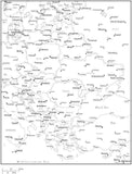
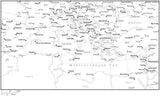
Black & White Eastern Europe Map with Countries, Capitals and Major Cities - E-EURO-533910
$ 29.95
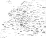
Black & White Europe Map with Countries, Capitals and Major Cities - EUROPE-533881
Black & White Europe Map with Countries, Capitals and Major Cities - EUROPE-533938
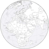
Black & White Globe over Africa & Europe Map with Countries
Black & White Mediterranean Map with Countries, Capitals and Major Cities - MEDITE-533912
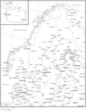
Black & White Scandinavia Map with Countries, Capitals and Major Cities - SCANDI-533892
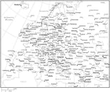
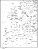
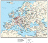
Black & White Western Europe Map with Countries, Capitals and Major Cities - W-EURO-533944
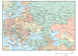
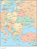
Black Sea Region Map with Countries Capitals Cities Roads and Water Features
$ 199.95
Digital Europe Map with Countries - Black & White
$ 19.95
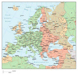
Digital Europe Map with Countries - Multi-Color
Eastern Europe Map Plus Terrain with Countries, Capitals, Cities, Roads, and Water Features
$ 99.95
Eastern Europe Map with Contours
$ 49.95
Eastern Europe Map with Countries, Capitals, Cities, Roads and Water Features
Eastern Europe Map with Country Boundaries, Capitals, Cities, Roads and Water Features
Europe Contour Map
Europe Map Plus Terrain with Countries, Capitals, Cities, Roads, and Water Features
Europe Map with Contours
Europe Map with Countries, Capitals, Cities, Roads and Water Features
Europe Map with Country Boundaries, Capitals, Cities, Roads and Water Features
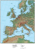
Europe Map with Land and Ocean Floor Terrain
Europe Map with Land Contours
Europe Map with Political Boundaries and Contours in the Water
Europe Map with Time Zones
$ 129.95
Globe Map over the North Atlantic with Contours
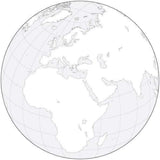
Globe over Africa & Europe Black & White Blank Outline Map
Globe over Africa & Europe Map Plus Terrain with Countries and Water Features
Globe over Africa & Europe Map with Countries and Water Features
Mediterranean Map Plus Terrain with Countries, Capitals, Cities, Roads, and Water Features
Mediterranean Map with Contours
Mediterranean Map with Countries, Capitals, Cities, Roads and Water Features
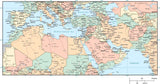
Mediterranean Map with Country Areas, Capitals, Major Cities and Roads
Mediterranean Map with Country Boundaries, Cities, and Roads
Multi Color Eastern Europe Map with Countries, Capitals, Major Cities and Water Features
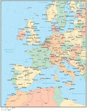
Multi Color Europe Map with Countries, Capitals, Major Cities and Water Features
Multi Color Globe over Africa & Europe Map with Countries
Multi Color Mediterranean Map with Countries, Capitals, Major Cities and Water Features
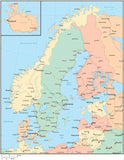
Multi Color Scandinavia Map with Countries, Capitals, Major Cities and Water Features
Multi Color Western Europe Map with Countries, Capitals, Major Cities and Water Features
Poster Size Europe Map plus Terrain
$ 399.95
Poster Size Western Europe Map
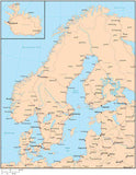
Scandinavia Map - High Detail
Scandinavia Map Plus Terrain with Countries, Capitals, Cities, Roads, and Water Features
Scandinavia Map with Contours
Scandinavia Map with Countries, Capitals, Cities, Roads and Water Features
Scandinavia Map with Country Boundaries, Capitals, Cities, Roads and Water Features
Single Color Europe Map with Countries, Capitals, Major Cities and Water Features
Single Color Globe over Africa & Europe Map with Countries
Single Color Mediterranean Map with Countries, Capitals, Major Cities and Water Features
Single Color Scandinavia Map with Countries, Capitals, Major Cities and Water Features
Single Color Western Europe Map with Countries, Capitals, Major Cities and Water Features
Western Europe Map Plus Terrain with Countries, Capitals, Cities, Roads, and Water Features
Western Europe Map with Contours
Western Europe Map with Countries, Capitals, Cities, Roads and Water Features
Western Europe Map with Country Boundaries, Capitals, Cities, Roads and Water Features
Western Europe Map with Land and Ocean Floor Terrain