California City Maps in Adobe Illustrator Format
Map Resources offers detailed maps of California cities. Our professional cartographers can create a map of any city or town area in California, quickly and affordably. Contact us today and tell us what you need.
First, Check our Stock US City Map Collection available for Immediate Download!
Accurate, Affordable and Fast!
Maps show an entire city, town, or township area with: highways, local streets, town areas, zip code areas, railroads, airports, lakes, and rivers, parks, golf courses, shopping malls, military bases, etc. See Map Resources Custom Maps to review detailed feature options & download sample maps.
Every city map we make is a vector format, layered and fully editable Adobe Illustrator file. This means:
- Your map is ready for high-resolution print
- You can change the color of every area fill
- You can change the color and weight of every line stroke
- All text is fully editable font text (not outlines)
City maps cost $250 and up, depending on the area and features needed. Discounts are available when you purchase 3 or more city maps.
Maps are delivered electronically in 2-5 business days.
Why Our Maps are the Best!
We license high quality street data to produce our custom city and town area maps, so you can be confident that your map will be accurate and up-to-date. Other companies use free US Census bureau maps, which are notoriously out of date, with many missing streets and incorrect street names.
California City / Town Area Maps
|
Adelanto, CA |
Half Moon Bay, CA |
Pomona, CA |
Or any other area you choose!
Download a Free Sample: |
View a Video: |
|
|
|
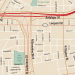
| Download Sample Local Street Map in Adobe Illustrator vector file format. |
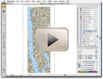
View a short video on using our |
Contact Us to Discuss Your Map Options
Please email us or call 609-397-1611 to talk with our staff. Just include the state and city or town name(s) describing the area you need, and how best to contact you, and we will get back to your with a quote ASAP.
For a sample download and more information please see our page on Map Resources Custom Maps.
Custom maps are available in two standard styles: one showing ALL local streets for a smaller area, and one showing just major roads for a larger area.
Local Street Maps show major roads and all local streets and street names. Also included, as appropriate, are: university campuses, golf courses, parks, cemeteries, hospitals, sports centers, shopping centers city areas, county boundaries, railroads, lakes and rivers. Maps are delivered in a standard cartographic style of colors and fonts, but are fully editable.
We can also make a street name index, listing every street name and its location on the map, for example "Main St ... G4".
Review detailed information and download a sample map in Adobe Illustrator format at our City with Local Streets info page.
Arterial road network maps show larger areas with major roads and, as appropriate: university campuses, golf courses, parks, cemeteries, hospitals, sports centers, shopping centers, city areas, county boundaries, railroads, lakes and rivers,. Local streets are not shown. Maps are delivered in a standard cartographic style of colors and fonts, but are fully editable.
Review detailed information and download a map in Adobe Illustrator format at our City with Arterial Roads info page.
Custom Maps are Affordable and Fast!
Our custom maps start at $250.
Maps delivered electronically in 2-5 business days.
About Map Resources
Map Resources has been supplying fine quality maps for graphic design since 1986. Over 30,000 designers, ad agencies, government agencies, and corporations use Map Resources. We pioneered the use of layers in design, creating vector images that users can edit quickly and easily.