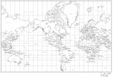
Mercator Projection World Map with Contours
$ 99.95
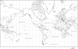
Black & White World Map with Countries Capitals and Major Cities - MC-AMR-253490
$ 49.95
World Black & White Map with Country Names in German
World Map - Europe / Africa Centered - Gall Projection
$ 199.95
Digital World Map with Countries - Black & White, Rectangular Map Projection
$ 19.95
Digital World Outline Maps - PowerPoint Collection
$ 99.00
World Black & White Map with Country Names in Dutch
Black & White World Map with Countries Capitals and Major Cities - MW-INT-253596
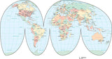
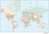
World Map - Multi Color Interrupted Projection, with Countries, Capitals, Major Cities and Water Features
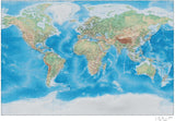
35 x 22 Inch Poster Size World Map - High Detail plus Grayscale Terrain - Europe Centered
$ 299.95
World Map with Land Contours - Americas Centered
Digital World Map with Countries - Mercator Europe Centered - Black & White
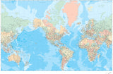
55 x 35 Inch Poster Size World Map - Mercator Projection with Countries US States Canadian Provinces plus Ocean Floor Contours
$ 399.95
World Map with Time Zones
World Map with Terrain - Mercator Projection - 11x17
World Map with Contours, Robinson Projection, Europe Centered
World Map - Europe / Africa Centered - Robinson Projection
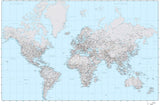
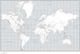
World Map with Political Boundaries and Contours in the Water
35 x 22 Inch Poster Size World map with Land and Water Terrain - Miller Projection
World Map in JPEG or Adobe Illustrator Vector Format - with Countries, US States, Canadian Provinces, Capital and Major Cities, and Roads - Europe / Africa Centered
World Contour Map
World Map Plus Terrain - Europe Centered Robinson Projection - RB-EUR-952909
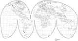
World Map with Polar Views
Digital World Map with Countries in the Mercator Projection - Multi-Color
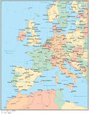
World Map - Multi Color Europe Center with Countries, Capitals, Major Cities and Water Features
World Map with Contours, Oval, Asia Centered
World Map - America Centered - with Countries, Capitals, Cities, US States, Canadian Provinces, and Roads
Premier International - World, Continent, and Region Maps
$ 499.00
World Map with Political Boundaries and Contours in the Water with Country Names in German
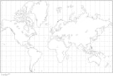
Digital Mercator Projection World Blank Outline Map - Black & White
World Map - Europe / Africa Centered - Winkel Tripel Projection
World Black & White Map with Country Names in Spanish
World Map with Terrain - Europe Centered Miller Projection
Single Color Globe over Africa & Europe Map with Countries
World Map Plus Terrain - Americas Centered Mercator Projection
World Map with Terrain - Miller Projection
Digital World Map with Countries - Interrupted Projection - Black & White
Black & White World Map with Countries US States and Canadian Provinces
World Map with Political Boundaries and Contours in the Water with Country Names in Spanish
World Map - Asia / Australia Centered - Winkel Tripel Projection
Black & White World Map with Country Names in German
Digital World Mercator Projection World Map with Countries - Black & White
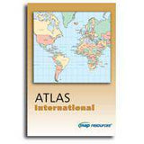
Atlas International - Illustrator Format
35 x 22 Inch Poster Size World Map - High Detail plus Grayscale Terrain - Americas Centered
Single Color World Map with Countries US States and Canadian Provinces
Digital World Blank Platte Carre Projection Outline Map - Black & White
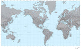
World Map with Contours
World Map with Land and Ocean Floor Terrain - Mercator Projection
Multi Color Western Europe Map with Countries, Capitals, Major Cities and Water Features
$ 29.95
World Heart Shaped Map in Red