USA Vector Maps
Digital Vector Maps of the USA available for Download 24/7
Adobe Illustrator Vector Format & PowerPoint Format
|
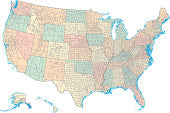
Black & White US Maps (21 Maps) |
Basic USA Maps (18 Maps) |

Traditional Maps of the US (24 Maps)Includes states, roads and cities. For a wide range of projects.$19.95 to 99.95
|
|
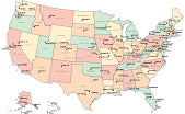
 US 2022 Congressional Districts (3 Maps) Maps of the 2022 US Congressional Districts. $199.95 to 299.95 |

Large, Detailed USA Maps (28 Maps) Huge, Detailed Digital Maps. Great for really large projects. $199.95 to 499.95 |
Maps with all US Counties (14 Maps) |
|
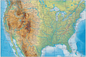
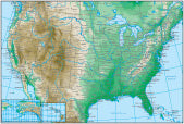
USA with Terrain (11 Maps) |
Topographic Contour US Maps (8 Maps) |
PowerPoint USA Maps (18 Maps) |


Did you want?
- North America - with Canada, Mexico & Central America.
- US States - showing each of the 50 states.
- US Region Maps - showing several adjacent states of the:
- US Counties - showing individual counties.
- US Cities - showing city downtown and metro areas.