Custom Map Services: Highways and Major Road Maps
Map Resources can produce a custom Major Road Map for (almost) ANYWHERE in the World!
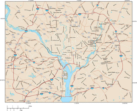
Arterial road maps show a network of major roads, along with other major features such as rivers, lakes, airports, parks, etc. Maps are delivered in a standard cartographic style.
Local Streets and Local Street names are not typically shown, but we can add them in if needed (see below).
In addition to the highways and major road network, and a scale bar, we also show: city areas, county boundaries, lakes and rivers, railroads, university campuses, golf courses, parks, cemeteries, hospitals, sports centers, and shopping centers.
Maps are delivered as layered Adobe Illustrator (.ai) vector files providing you with the flexibility and the versatility you need to accomplish your design goals. To order please call, email, or fax us this Custom Map Order Form.
|
|
Download Sample Major Road Metro Map Open this map in Adobe Illustrator (CS3 or higher) to see the map features, detail, and layers we build into all our maps. Note that the map is fully editable so you can quickly alter the appearance to your design specifications, including all color fills, line specifications, and font text (not outlines!) The download includes the Adobe Illustrator format file, plus a PDF copy you can view in Adobe Reader, and a "Simple" map style we can also make with many of the extra features removed at a lower cost. |
Cost Estimates for Major Road Metro Maps
Map Area (approx) Size of Map Cost
10 x 10 miles (100 sq-mi) 5 x 5 inches $250
15 x 15 miles (225 sq-mi) 8 x 8 inches $325
20 x 20 miles (400 sq-mi) 10 x 10 inches $375
20 x 30 miles (600 sq-mi) 10 x 15 inches $425
30 x 40 miles (1200 sq-mi) 15 x 20 inches $550
40 x 50 miles (2000 sq-mi) 20 x 25 inches $650
Over 2000 square miles call or email
Note: we use a scale requiring 1 inch of page per 2 miles mapped. This scale maximizes labeling and legibility.View Custom Major Road Metro Map Cost Estimates based on Kilometers.
Royalty Free License
Cost includes Map Resources Standard Royalty Free License. You are permitted to use the maps for most print, web, broadcast and electronic media. The license is granted on a perpetual basis, with no renewals, and no production limits.
Special Options for Major Road Metro Maps
-- Local Street Lines and Names. Local Street lines: +$100 for up to 1,000 sq-mi, +$50 per additional 1,000 sq-mi. Local Street Names (may overlap): +$100 for up to 1,000 sq-mi, +$50 per additional 1,000 sq-mi. ]
-- Index. We can provide an Index that lists the features and street labels along with their location on the map relative to a grid, for example "Main St ... B4" meaning that Main Street can be found in map grid cell B4. The Index is provided as a separate text document (txt), so you have flexibility on how you format your Index. The fee for the Index varies with area, typically from $50 for under 10 square miles to $250 or more for very large areas.
-- Points of Interest Locations (POI).
We can add your Custom Locations to your map! You supply the addresses for each location as an Excel or text data file, and we geo code the location and place it on your map, with a text label if needed. $100 for up to 100 locations in the first class / layer, $50 per additional 100 or each additional class / layer. For example if you have 150 locations in two classes, that would be $100 for the first 100 points and first class / layer + $50 (for the second 100 locations) + $50 (for the second class / layer) for a total of $200.
-- Terrain Background. We can add a 300 dpi grayscale shaded relief image for most areas. This roughly doubles the cost, because it is an entirely separate process, which must then be matched to the vector features in the Adobe Illustrator map. Please call or email for pricing.
- US County Overview map. For larger areas a US county map may be a more cost effective solution, covering either a single county or several adjacent counties.
Test Out a Sample Major Road Metro Map - Download a Sample Major Road Metro Map
Open the sample map with Adobe Illustrator and evaluate the map features and layers. All features on the map are fully editable layers you can turn on or off. Areas are complete objects you can select and modify, add color, etc. All lines are fully editable. All text is fully editable font text (not outlines). Please note you must have Adobe Illustrator CS3 or later to open and work with the sample map.