World Vector Maps
Best Quality World Maps in Adobe Illustrator format. Layered and Fully Editable. Simple country borders to High Detail with terrain, major roads, rivers, cities, etc. Download 24/7.
 |
 |
|
|
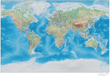
World Maps with Terrain (31 Maps) Dramatic physical appearance. CMYK
|
Large & Detailed World Maps (23 Maps) 22 x 35 and larger that can scale up to even bigger projects: Wall maps, trade show booths, and projects requiring intricate detail. Some even include states & provinces. |
Also works with Keynote. Use as-is, or change colors to show your info. Page size is perfect for reports, proposals, presentations, etc.
|
|
 |
 |
|
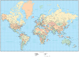
World Maps with Cities & Highways
(47 Maps) Each country an object, plus capitals, major cities, roads, lakes, rivers, etc. Easy to edit. |
World Maps with Topographic Contours (35 Maps) Attractive contour background ideal for natural history projects, museums, zoos.
|
Black & White World Maps (48 Maps) Plain and simple. Each country an object you can select and change color.
|
 |
 |
 |
|
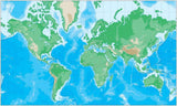
Just Continent Outlines (36 Maps) Just Land and Water. No text or country borders. |
World Maps with Time Zones (3 Maps) Perfect for airlines, calendar and diary publishers. |
Simple World Maps with Country Areas (26 Maps) Basic world maps with each country an object you can select and color. |

Need a Specific World Map Style or Projection?
Browse our Entire Collection of Over 180 Digital World Maps:
 Rectangle Shaped (41 Maps) |
 Globe and Oval Shaped (47 Maps) |
 Barrel Shaped (5 Maps) |
|
Time Zone (3 Maps) |
 Upside-Down World (1 Map) |
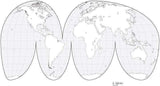
 Interrupted World (7 Maps) |
Need 3 or more maps? Check out our Collections
(You can still download right after your purchase.)
|
|
|
|
|


