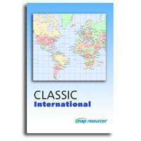
Classic International
About This Map Collection
Convenient, attractive page size maps of the world, continents, and world regions. Each map shows national capitals and major cities, major highways connecting cities, and major water features. Each in a variety of color styles.
Classic International includes 37 world/region maps, each in several color styles:
- 5 World maps
- 7 Globes
- 7 Continent Maps
- 18 Region Maps (Western Europe, SE Asia, Caribbean Sea, etc)
You can preview one of each Classic International map.
Maps are Adobe Illustrator vector files with features in separate layers. All map features are fully editable so you can use the maps as-is change or add color rescale the map or modify specs to suit your design needs. All text is editable font text not outlines.
The entire collection is available for immediate download when you purchase online.
Royalty Free for print and web.
Download is a 200 MB ZIP archive.
How Will I Download My Digital Map File?
Your receipt page will have a link to download your file, and you will receive an email with the same link. The link will be active for 30 days.
30 Day Money-Back Guarantee!
Download a Sample Map
See for yourself why our maps are the best! Download a fully editable sample map in Adobe Illustrator or PowerPoint Format.
Can't Find the Map You Need?
We can make one for you. Here's how to get a custom map...
Similar Maps