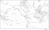
World Map with Land and Ocean Floor Terrain with Country Names in German
About This World Map with Terrain and Country Names in German
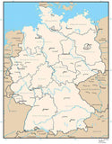
Includes terrain relief image in the land with country borders and country names in German.
In Illustrator format the background terrain is a 300 dpi CMYK Photoshop file so you can alter the background colors easily to your design specifications.
Perfect for color illustrations in print or web design.
This world map is in the Mercator Projection.
Weltkarte mit Land und Ozean GelÌ_nderelief Bild mit deutschen LÌ_ndernamen
Enthält Geländeentlastungsbild im Land mit Landesgrenzen und Landesnamen auf Deutsch.
Im Illustrator-Format ist das Hintergrund-Terrain eine 300 dpi CMYK Photoshop-Datei, so dass Sie die Hintergrundfarben leicht zu Ihren Design-Spezifikationen ändern können. Perfekt für Farbabbildungen im Print- oder Webdesign. Diese Weltkarte ist in der Mercator Projektion.
Perfekt fÌ_r Farbfotos in Papier drucken oder Web-Grafik.
Diese Weltkarte ist Mercator-Projektion
How Will I Download My Digital Map File?
Your receipt page will have a link to download your file, and you will receive an email with the same link. The link will be active for 30 days.
30 Day Money-Back Guarantee!
Download a Sample Map
See for yourself why our maps are the best! Download a fully editable sample map in Adobe Illustrator or PowerPoint Format.
Can't Find the Map You Need?
We can make one for you. Here's how to get a custom map...
Similar Maps