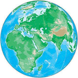
Poster Size Middle East Map plus Terrain
About This Middle East Terrain Map
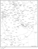
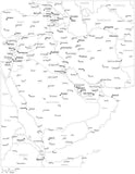
This map shows the entire area in the preview image, with Adobe Illustrator vector art layers (see below) including country borders, major cities, rivers, and roads. The background is a terrain relief image.
This large size map file is drawn at 33 x 23 inches, and the background terrain is a fully editable 300 dpi (9900 x 6900 pixel) CMYK Photoshop file. Using the tools in Photoshop you can alter the background colors easily to your design specifications.
Shows all of: Afghanistan, Armenia, Azerbaijan, Bahrain, Cyprus, Djibouti, Eritrea, Georgia, Greece, Iran, Iraq, Israel, Jordan, Kuwait, Kyrgyzstan, Lebanon, Nepal, Oman, Pakistan, Qatar, Romania, Saudi Arabia, Sri Lanka, Syria, Tajikistan, Turkey, Turkmenistan, United Arab Emirates, and Yemen.
Perfect for large color illustrations in print or web design.
How Will I Download My Digital Map File?
Your receipt page will have a link to download your file, and you will receive an email with the same link. The link will be active for 30 days.
30 Day Money-Back Guarantee!
Download a Sample Map
See for yourself why our maps are the best! Download a fully editable sample map in Adobe Illustrator or PowerPoint Format.
Can't Find the Map You Need?
We can make one for you. Here's how to get a custom map...
Similar Maps