Manhattan Island Adobe Illustrator Vector Map File - 65 square miles - with Local Streets
About This Manhattan Island Digital Vector Map
Manhattan Island (Kings County, NY) and surrounding area showing all arterial and major roads and every local street, downloadable in layered, editable Adobe Illustrator vector file format.
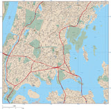
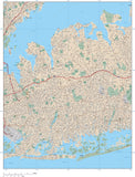
Use the preview image at left to view the entire map area in low resolution, and a second preview image shows a smaller area at high resolution. Of course, the entire map area is provided as a vector format Adobe Illustrator file.
The road network is labeled with road names and numbers. Also shown are a variety of features including parks, hospitals, shopping centers etc.
View all our New York City maps including each of the 5 boroughs together and separately with every street, and the entire metro area with just the major roads.
In Illustrator format all areas and streets are fully editable and all text is font text (not outlines). Layers make it easy to customize the appearance of the map using the tools in Adobe Illustrator.
Dimensions about 12 x 36 inches. Map is about 5 x 13 miles, about 65 square miles.
Perfect for reports, proposals, presentations, wall graphics, or destination marketing projects.

See a short video on using this
New York City map in Adobe Illustrator
in the following formats:
If you need a map like this one showing a different area please contact our Custom Mapping Services.
How Will I Download My Digital Map File?
Your receipt page will have a link to download your file, and you will receive an email with the same link. The link will be active for 30 days.
30 Day Money-Back Guarantee!
Download a Sample Map
See for yourself why our maps are the best! Download a fully editable sample map in Adobe Illustrator or PowerPoint Format.
Can't Find the Map You Need?
We can make one for you. Here's how to get a custom map...
Similar Maps