Menu
Cart 0
Detailed Alabama Digital Map with Counties, Cities, Highways, Railroads, Airports, and more
Move your mouse over image or click to enlarge

Detailed Alabama Digital Map with Counties, Cities, Highways, Railroads, Airports, National Parks and more

  • $ 129.95


More License Info

About This Alabama Digital Map

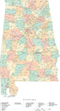
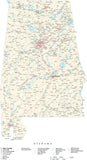
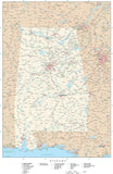
Detailed Alabama state map includes all counties, major highways and roads, rivers, lakes, city and town locations. Shows the entire state, with portions of adjacent states.

Created in Illustrator format, each county is a separate object you can select and change the fill color. All lines are fully editable, and all text is fully editable font text (not outlines). See Layers/Features tab below for full list.

Great for posters, trade show displays, or any other project that requires large format graphics.

This map is also included in our Premier USA - High Detail collection, including maps of the USA and all 50 states.

If you need a map like this one showing a different area, please contact our Custom Mapping Services.

Adobe Illustrator Layer List on This Map

  • Airports
  • Boundary Case
  • Canals
  • Cities - No Pop Data
  • Cities 0-999
  • Cities 1 000-3 999
  • Cities 10 000-24 999
  • Cities 100 000-249 999
  • Cities 25 000-49 999
  • Cities 250 000-499 999
  • Cities 4 000-9 999
  • Cities 50 000-99 999
  • Coastline
  • County Areas
  • County Boundary Case 1
  • County Boundary Lines
  • County Name Text
  • County Seat Symbols
  • Dams
  • Frame
  • Grid
  • Intercoastal Waterway
  • Intermediate Lakes
  • Intermediate Rivers
  • Interstate Highway Numbers
  • Interstate Highway Symbols
  • Interstate Highways
  • Lake Name Text
  • Lat./Long. Degrees
  • Legend
  • Major Lakes
  • Major Rivers
  • Metro Areas
  • Military
  • Military Name Text
  • Minor Lakes
  • Minor Rivers
  • National Forest
  • National Forest Name Text
  • National Park
  • National Park Name Text
  • Ocean Fill
  • Ocean/Bay Name Text
  • Railroads
  • River Name Text
  • State Areas
  • State Boundary Lines
  • State Capitals
  • State Name Text
  • State Road Numbers
  • State Road Symbols
  • State Roads
  • Tick Marks
  • Toll Roads and Bridges
  • US Highways
  • US Road Numbers
  • US Road Symbols
  • Wildlife Refuge
  • Wildlife Refuge Name Text

How Will I Download My Digital Map File?

Your receipt page will have a link to download your file, and you will receive an email with the same link. The link will be active for 30 days.


30 Day Money-Back Guarantee!


Download a Sample Map

See for yourself why our maps are the best! Download a fully editable sample map in Adobe Illustrator or PowerPoint Format.


Can't Find the Map You Need?

We can make one for you. Here's how to get a custom map...


Similar Maps