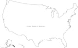
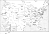
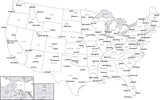
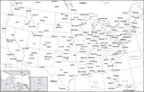
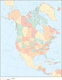
United States Black & White Map with States and State Names
About This USA Map with States and State Names
Shows the USA, and all 50 states, with state names.
In Adobe Illustrator format all areas and lines are fully editable, and all text is font text (not outlines). You can easily customize the map using the tools in Illustrator ,such as make the map larger or smaller, and fill states with colors.
In Powerpoint format each state is an independent object which is fully editable, and all text is regular editable text. Easy to customize using the tools in Powerpoint, such as fill states with colors. Also works in KeyNote.
Dimensions about 5.75 x 9.25 in (15 x 24 cm). Perfect for page size illustrations in proposals or reports.
Albers Equal Area Projection.
This map is also included in our Atlas USA collection, including similar style maps of the USA and all 50 States in several projections.
How Will I Download My Digital Map File?
Your receipt page will have a link to download your file, and you will receive an email with the same link. The link will be active for 30 days.
30 Day Money-Back Guarantee!
Download a Sample Map
See for yourself why our maps are the best! Download a fully editable sample map in Adobe Illustrator or PowerPoint Format.
Can't Find the Map You Need?
We can make one for you. Here's how to get a custom map...
Similar Maps