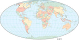
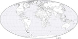
World Maps in PowerPoint Format
Map Resources PowerPoint format maps are editable PPT files that allow you to create compelling graphics for your presentations. They can be opened and edited in any recent version of PowerPoint or Keynote. They are vector art, so they look sharp on screen and in your handouts.
All our World Maps are ready to use as-is, and fully editable so you can change the colors, lines, and text on the map.
Some just show the continent outlines, and others have each country an object you can select and color independently. Great for adding that international flair to your presentations!
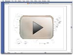
The best way to see how the PPT maps work is to download a sample and try it yourself. Edit the map, then bring it into a presentation and see how it looks.
|
With Map Resources PPT maps, we make it easy to add compelling map graphics to your presentations. They are vector art, so they look sharp on screen and in your handouts.
And since each area (country, state, county) is an object you can select and change color, size, etc.
You can add stars, banners, charts or other elements to enhance your presentation.
|
 |
 |


Results 1–3