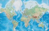
World Map - Multi Color Europe Center with Countries, Capitals, Major Cities and Water Features
About This MapWorld Map
Shows the country outline with country name and major cities.
In Illustrator format each country is a separate object you can select and change the color. All text is fully editable font text (not outlines).
Drawn at a nominal size of about 7x10 inches, this map is perfect for page size illustrations in proposals or reports.
This map is in the Mercator projection.
This map is also included in our Classic International collection, including similar style maps of the World, all seven continents, and sub-continent regions.
How Will I Download My Digital Map File?
Your receipt page will have a link to download your file, and you will receive an email with the same link. The link will be active for 30 days.
30 Day Money-Back Guarantee!
Download a Sample Map
See for yourself why our maps are the best! Download a fully editable sample map in Adobe Illustrator or PowerPoint Format.
Can't Find the Map You Need?
We can make one for you. Here's how to get a custom map...
Similar Maps