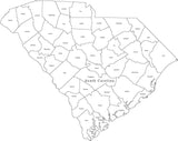
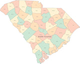
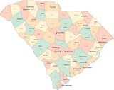
Digital South Carolina Map with 2022 Congressional Districts
About This Digital South Carolina Map with 2022 Congressional Districts
The Congressional District Boundaries on this map were used for the 2022 elections, and will be used until 2030. They will be updated using results of the 2030 US Census.
Each district is an object that can be selected and modified (change color) as needed, and the district numbers also appear on the map.
Adobe Illustrator & PDF Formats
Use any of the tools in Adobe Illustrator to edit the map - you can change the color of the districts, re-size the map, print the map, etc. Or you can view the PDF map in Adobe Acrobat or many other applications that work with PDF format files.
Need All 50 States?
We also have a collection which includes All 50 US State Maps with Congressional Districts.
If you need a single map showing all 50 states, consider one of our USA maps with Congressional Districts.
Need a Single District?
If you need a map showing a single congressional district with more detail, please contact our Custom Mapping Services.
How Will I Download My Digital Map File?
Your receipt page will have a link to download your file, and you will receive an email with the same link. The link will be active for 30 days.
30 Day Money-Back Guarantee!
Download a Sample Map
See for yourself why our maps are the best! Download a fully editable sample map in Adobe Illustrator or PowerPoint Format.
Can't Find the Map You Need?
We can make one for you. Here's how to get a custom map...
Similar Maps