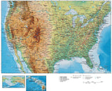
USA Maps with Terrain
All Map Resources Terrain Maps are made of two linked map files:
A High Resolution Photoshop Terrain Background Image:
The Photoshop file with the "Background Relief Image" shows shaded relief terrain. This is a separate, linked high-res Photoshop image file, 300 ppi in 4-channel CMYK color. This Photoshop file can be opened and modified using and version of Adobe Photoshop. The CMY (Cyan, Magenta, Yellow) channels show the color tints, and the K (black) channel shows the hill shading. Each channel can be modified separately in Photoshop to give a wide variety of map styles and appearances.
With Adobe Illustrator Vector Map Line and Text Features:
Download a Terrain Sample Map. Note: You need Adobe Illustrator CS3 or higher to open the full Terrain map.


Results 1–1